Tuesday, June 15, 2021

Solastalgia

Today the late-afternoon sun in Phoenix is casting a sickly, yellow pall over the city. It's due to smoke from a wildfire sixty miles to the east of downtown Phoenix, which as of this writing has consumed 123,000 acres of high desert, oak and juniper woodland, and Ponderosa pine forest.

Human-caused, as most Arizona wildfires are.

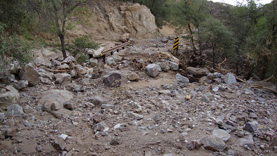
Last year another human-caused wildfire rolled across 193,000 acres of similar terrain, doing particularly grievous damage to stands of mature saguaro cacti, Arizona's most iconic plant. Most will not recover.

Arizona's Upland Sonoran Desert, noted for its saguaros, cholla cactus, prickly-pears, and palo verde, mesquite, and ironwood trees, and many other species, is not adapted to fire. The desert did not burn until humans introduced non-native grasses to improve the conditions for cattle grazing, with the unintended side effect of providing an excellent medium for wildfire ignition and growth.

After fire, this landscape does not regenerate. It is replaced by a grass-dominated landscape novel to Arizona. Wherever fire burns, the Upland Sonoran Desert is gone forever.

The woodlands at higher elevations were not only adapted to lightning-started wildfire but thrived on it. Early forest policy, in response to the fires of the "The Big Burn" in the U.S. West in 1910, called for suppression of all woodland blazes as quickly as possible.

The story is now familiar to Americans who pay attention to the forests. Fuels build up in the woodlands. Low-intensity fires, which once cleaned up the forest floor, suppressed the growth of shrubs and small trees, and cycled nutrients back into the soil, have been absent. Heavy fuel loads now combine with hotter and drier weather and human ignition to create unnatural fires of colossal size and intensity.

Ponderosa pine reseeds slowly from the margins of burned areas, and closing the wound may take many decades or even centuries. And a hotter climate may make pine regeneration all but impossible.

These fires have cleared entire Arizona mountain ranges of their trees, something that, thirty years ago, I would not have thought possible. The roll of losses is staggering and depressing: The forests of the Santa Catalinas and the Chiricahuas -- mostly gone. The isolated stands along the top of the Mazatzals -- gone.

And last night and tonight the pretty forest atop the Pinal Mountains south of Globe is going up in smoke.

Elsewhere the Santa Ritas, the Pinaleños, and the Sierra Ancha have all been touched by flame, in places severely. The gems that were Escudilla Mountain and the eastern White Mountains -- gone or reduced to relict stands. Much of the forest of the eastern Mogollon Rim country -- gone. 

I cannot now hike anywhere in Arizona, in remaining unburned terrain, without thinking that the landscape is temporary and fated for destruction. It's when and not if. The joy I take in the landscape is now shaded by elegy.

This uniquely beautiful and biologically diverse landscape has also seen a catastrophic increase in human impact. In my lifetime Arizona has grown from 1.3 million residents to well over 7 million. Outdoor recreation takes a heavy toll. Outdoor recreationists start fires.

This afternoon's yellow sky made me think that I am seeing the future, one of unnatural heat and fire, of dry mountain rivers, of relict stands of pines and saguaros: Degradation everywhere.

Not long ago I encountered a word that means the homesickness you feel when you are still at home but your home has changed beyond recognition. Your homesickness is for a world lost.

A little searching and I found it again: Solastalgia. It is a coinage by environmental sciences professor Glenn Albrecht, derived from Latin solacium (comfort) and Greek algia (pain) -- pain from the loss of solace.

I no longer recognize Arizona. It is a world irrecoverably lost.


Saturday, July 23, 2016

Monsoon

I have prided myself on writing about our summer rainy season twice (see El día de San Juan and Waiting, below) without using the word "monsoon."

In the last few decades the word has come into use by local journalists and television weather people, but when I was a kid in Phoenix in the 1960s I never heard it. And when it began to be used to refer to our summer rains, I found it laughable. "Monsoon" conjured up images of what occurs in India, which is a June-through-September rainy season producing an average of 35 inches across the subcontinent, whereas the summer rains in Phoenix have averaged 2.71 inches according to weather records going back to 1896.

Now 2.71 inches is a big deal in our parched corner of the Sonoran Desert, but "monsoon"? Gimme a break.

But it turns out that our weather does indeed follow the same pattern as the one that forms over the Arabian Sea and which affects India. The word "monsoon" derives from Arabic mausam, meaning "season," as the rains are caused by a seasonal shift in winds. What happens there also happens here in the Southwest, though our inputs of moisture-laden air are lower. (And what you get in the Southwest is dependent on location. Usually, the higher up you are, the wetter. Thus Tucson, 1200 feet higher than Phoenix and tucked into a corner formed by two high mountain ranges, averages 6.08 inches, June through September.)

So, OK then -- The Arizona (a.k.a. Southwestern or North American) Monsoon.

Here's how it works.

In May a dome of high pressure develops and is centered over the Mexican Northwest, and this high pressure system continues to affect the Phoenix area well into June. It pushes away inflows of air. It is during this time, under a bright and relentlessly cloudless sky, that we will have single-digit humidity readings and often set records for high temperatures. June is the month in which a local TV station will typically perform the stunt of attempting to fry an egg on an incandescent Phoenix sidewalk.

But by late May mountain surfaces in Mexico heat up and cause air to rise, drawing in moister, denser air from the Gulf of California. The resulting low-pressure area pushes the high pressure system off to the northeast, from the Mexican highlands eventually to west Texas.

The clockwise flow of air around this high pressure area begins to move moist air from Mexico and the Gulf of California into Arizona and New Mexico. Higher-level winds circling around the high and carrying moisture from the Gulf of Mexico also contribute to this flow. Meanwhile, the low-pressure area that has formed in Mexico -- often over the northern Baja Peninsula and having a counterclockwise flow -- also serves to move moist ocean air northward. A great atmospheric funnel, mouth end over Mexico and spout end over the U.S. Southwest, has formed.

The specifics of the locations of high- and low-pressure areas may vary, but the basic mechanism is a seasonal shift in air flows, from dry westerlies to moisture-laden southerlies. Propelled by differences in ocean and land surface temperatures, pressure systems are created which serve to move moist air from south to north.

The change always begins in Mexico. Heavy rains begin to appear over the Sierra Madre Occidental. By late June, as the high pressure system moves to the north and northeast, rains typically begin to appear over southeastern Arizona's high, isolated mountain ranges. By early July the pattern moves into Phoenix and the central Arizona highlands as well as into New Mexico. The summer rains come to Tucson, Phoenix, Flagstaff, El Paso, Las Cruces, Albuquerque, and Santa Fe -- the fabled Seven Cities (if not of Gold at least of Fast Food and Subdivisions).


A thunderstorm boils up over the high country north of Phoenix on July 1, 2016.
Taken by the author from the entrance to the Musical Instrument Museum

at North Tatum and East Mayo Boulevards.
Individual thunderstorms develop when moist air, heated by the desert floor, expands and rises. As it moves with the seasonal flow to the north and northeast, it encounters mountains and is thrust up into colder air at high altitude, causing condensation -- that is, clouds. This is why on hot monsoon afternoons in Phoenix I can see towering thunderheads over distant mountains.

Sometimes those masses, now heavy with water droplets, will collapse, causing a storm to charge out of the mountains and onto the deserts, often pushing air ahead of it -- a microburst.

The location and timing of the rains is highly variable, both from year to year and within the season itself, and so, lacking consistency, are the subject of endless speculation, conversation, and hope. Recent arrivals laugh at our obsession with what would be piddling rainfalls back in Illinois. They don't get it yet.

Find more detailed explanations of the mechanism at South West Weather (with nice graphics showing the pressure systems and air flows) and the CLIMAS Project.


Tuesday, July 05, 2016

Worried about the canyon

Rain, sometimes heavy, fell on my canyon last week and on the surrounding burned area in the Sierra Ancha. An update from the Forest Service on the status of the fire notes that "there is periodic localized flooding occurring in several drainages west of the burned area including Reynolds Creek, Workman Creek, Pocket Creek, Parker Creek, and Cottonwood Creek. ADOT is monitoring the creek crossings of SR 288 for potential damage to the highway infrastructure."

I also note that the USGS stream gauge on South Parker Creek was knocked offline on one of the storm days, June 27, and has remained offline.

So the Arizona Department of Transportation is checking the places where State Highway 288 crosses the Sierra Ancha's streams for flood damage, and some event in South Parker Canyon was big enough to incapacitate the gauge.

What may this mean? I am, of course, thinking about large, post-fire debris flows. (A debris flow is a slurry of water, rock fragments, soil, and mud.)

The USGS Landslides Hazards web page notes that "wildfire can significantly alter the hydrologic response of a watershed to the extent that even modest rainstorms can produce dangerous flash floods and debris flows."

Results of a post-wildfire debris flow at Carr Canyon Bridge,
Huachuca Mountains, Arizona. Photo courtesy InciWeb/
National Wildfire Coordinating Group
After receiving assurances that the fire was low to moderate in severity and beneficial to long-term forest health, I was surprised to see indications that there may have been flooding and debris flows large enough to damage man-made infrastructure and, more worrisome to me, scour canyon bottoms and choke them with rocks and sediment.

My surprise was due to a lack of knowledge.

With a little research I found
Debris-Flow Hazards and Related Phenomena by Matthias Jakob and Oldrich Hungr (Springer/Praxis, 2005) and its observations pertinent to my concerns (Chapter 15,"Wildfire-related debris flow from a hazards perspective," pp. 373-375).

High gradients of terrain and removal of litter and duff (needles, cones, dead branches, etc.) from the forest floor predispose a watershed to flash-flooding and debris flows. The Sierra Ancha Range has steep gradients in abundance, and even moderate-severity wildfire removes protective and absorbent litter and duff. Just because a watershed does not experience a high-severity burn doesn't ensure that it will avoid the kind of runoff that produces floods and debris flows.

So I will continue to worry about long-term damage and wonder what has happened in the Reynolds, Workman, Pocket, and Parker Creek watersheds. Obligations will keep me city-bound for another week or two, but I should be able to go see the situation for myself soon.

Sunday, June 26, 2016

Fire returns to the canyon

Can a person fall in love with a canyon? Every year thousands of visitors fall in love with the Grand Canyon, though the areas of the South Rim developed for tourism have a lot more in common with Disneyland than they do with wilderness. But Arizona is laced with innumerable canyons, large and small, so one can be a suitor to many.

My longtime love is an obscure canyon in central Arizona carved out of Precambrian limestone, diabase, and quartzite by the South Fork of Parker Creek. A three-mile hike along a scenic trail takes you from 4900 feet to 6900 feet at canyon's rim. The canyon is aligned east-west, so its north wall faces south and is shrubby and sere, and its south wall faces north and is a different, wetter world of Ponderosa pines and Douglas-firs. In Arizona, exposure is everything.

A magical canyon in the sky.
(Click to enlarge.)
A not-quite-year-round stream supports a biologically rich bottom with alders, sycamores, and oaks, with golden columbines, and with frogs! (Hyla arenicolor, the Canyon Tree Frog.) Visitors include mule deer, American black bears, elk, and wild turkeys. I have also encountered an animal of Mexico and southern Arizona that the nature guides say shouldn't be as far north as Parker Canyon -- Nasua narica, the coati.

It is a magical place.

And one I have grown jealous and possessive of. I have come to see myself as a sort of mayordomo of the South Fork of Parker Canyon, personally accountable for a natural watercourse and the path that follows it. A few seasons ago I assigned myself a workday in the canyon and went up with work gloves, shovel, and two handsaws. I cleared smaller deadfall off the trail and patched two places where storm runoff had made cavities in the footpath. Every hike up the canyon also means taking along a garbage bag so I can pick up what other hikers have left behind. Along the South Fork, the situation isn't too bad -- it is a lightly used trail.

I was back in the canyon last September, introducing it to a longtime friend. My patches have held fine, but more dead trees had fallen across the trail. I need to buy a chainsaw!

About 1.2 miles up-canyon, at 5600 feet, is an ancient alligator juniper with deep burn scars. I have both contemplated and affectionately patted that tree and thought that Parker Canyon most certainly has had fire in the past, though the Forest Service has no record of fire in this canyon since it started keeping records 90 years ago. But the Forest Service does have two long-established fire lookouts in the area. With misplaced good intentions, modern man excluded fire.

Until now.

My magical canyon burned from rim down to trailhead from June 7 to June 11.

Wildfire in the Sierra Ancha of central Arizona,
June 2016. Photo courtesy U.S. Forest Service.


Fallen trees, limbs, needles, and cones had built up to dangerous levels; sickly Ponderosa pines and Douglas-firs crowded one another; the forest floor, deprived of sunlight, was barren of herbs and grasses in too many places. Parker Canyon not only burned again but needed to burn again.

This is current orthodoxy in fire science and I hope it is true, for I still find myself mourning for Parker Canyon. We humans have a hard-to-shake habit of regarding fire as destroyer rather than creator.

But I do believe in the new faith in fire. Men and women with experience and expertise have solid reasons to see fire in a new way. And the ancient juniper tells me that fire was once a regular visitor -- an agent that periodically recycled dead wood into the soil and renewed the South Fork of Parker Canyon. I need only read the history told by the old tree's burn scars.

All the roads and trails into the burn area are closed now and will be for some time while Forest Service crews take measures to control erosion during our soon-to-arrive summer rainy season. A ranger with whom I was in contact during the fire assured me that it was exactly the kind of fire that was needed -- mostly low in burn severity and consuming deadfall, needle buildups, small sickly trees, and dry underbrush. She said that the canyon and the larger federal wilderness area in which the fire burned won't look so good initially but that the long-term effects will be beneficial to forest health.

I hope so. 

In due course I will return to the South Fork of Parker Canyon. I will be interested to see for myself just how the canyon has responded to fire's return. I hope I will see surviving and even flourishing large conifers in a more open forest, with more herbs and grasses under the trees taking advantage of sunlight and the nutrients fire has returned to the soil.

The canyon has burned. Long live the canyon.


Saturday, June 25, 2016

El día de San Juan

Yesterday, June 24th, was the Day of Saint John the Baptist, traditionally regarded as the first day of summer (and the first day on which one can expect rain) among the native and Hispanic peoples of the Southwest (see my post, Waiting).

During the afternoon and evening of the 23rd, we had a flow of moist air move up from the Sierra Madre into Arizona. Though no rain was produced over the deserts, one could see promising clouds to the north and east over Arizona's central and eastern highlands.

No rain yet in Phoenix, but distant
thunderheads signal a change.

And on the afternoon of the 24th, as if on cue, I heard my first Apache cicada of the season, a male singing in my neighbor's ash tree. Again clouds could be seen far away to the north and east.

Rain may be imminent; rain may wait several more weeks. But change is in the air. The cicadas seem to sense it, the slight increase in moist air perhaps their signal that it is time to emerge from their three-year-long sojourn underground.

I couldn't sleep well the night of the 23rd/24th and at 2 am I stepped outside. Down the street a male mockingbird was singing, his relentless nighttime serenade another sign of southern Arizona summer.

I went back to bed, but he probably kept it up until almost dawn, as his kind do, for they are trying to demonstrate their fitness as potential mates by stalwart singing. And, yes, they do earn their name by mimicking sounds from their environment, and not just the songs of other birds. My male down the street was doing car alarms.

The evening of the 23rd also brought a visit from a new Gambel Quail family -- mom, dad, and four chicks. Our regularly visiting family with 15 (!) chicks did not put in an appearance, though we see them once or twice a week.

We were above 110 degrees for our afternoon high temperature all week long.  But the promise of distant clouds and the song of the cicada -- the signatures of life in Sonoran Desert summer -- tell me my wait this year is over.

Wednesday, June 08, 2016

Further thoughts on the 
idea of wilderness

The National Wilderness Preservation System comprises 765 designated areas under the administration of the National Park Service, U.S. Forest Service, Bureau of Land Management, and U.S. Fish and Wildlife Service. I am grateful that the system exists, and grateful that biologically and geologically significant natural landscapes have been set aside as havens from resource extraction, road building, and motorized vehicles.

But the Wilderness Preservation System is fragmented. Many units are small. They are affected by the activities that take place in the landscapes that surround them. They are not truly wild places. Human activity seeps into them and has done so for a very long time.

My favorite one, the Sierra Ancha Wilderness of central Arizona, is a gem, although a small one of just 20,850 acres. That may sound like a lot, but this unit is only about six by eleven miles in extent and irregularly shaped, with one spot pinching down to less than a mile in width. Around it are roads, ranches, summer home developments, telecommunication facilities, and uranium prospects. I have easily walked right across the Sierra Ancha Wilderness in the course of a day hike. You can make cell phone calls from the middle of it.

To my way of thinking, a so-called wilderness can't really be wilderness unless it is something like the size of Connecticut -- 5000 square miles, say. Alaska can have wildernesses; the other states, not so easily.

To those contemplating use of our federally protected wilderness areas, I would say that generally they are a lot smaller than you think they are and that your impacts will be a lot bigger than you think they will be.

You should consider this and act accordingly.

Tuesday, June 07, 2016

Farewell to wilderness

Yesterday morning I encountered an arresting headline on the Washington Post's website:

Scientists say that ‘nature,’ untouched by humans,
is now almost entirely gone

Post reporters Chris Mooney and Brady Dennis cite a study just published in the Proceedings of the National Academy of Sciences in which its authors note that " 'pristine' landscapes simply do not exist and, in most cases, have not existed for millennia."

This resonated with me because a few seasons ago, while hiking in the federally designated Kachina Peaks Wilderness north of Flagstaff, I encountered not only other hikers but the debris that hikers leave in their wake: empty water bottles, mylar food wrappers, toilet tissue, assorted unidentifiable bits of plastic, and so on.

Some pristineness. Some wilderness.

This and similar encounters with what I call the Great Backcountry Garbage Patch have led me to conclude that the idea of wilderness is dangerous.

Much of Arizona off the interstates and major highways -- which is to say most of it -- looks like wilderness, though upon close inspection one finds that all of it has been altered by human activity: burning and other modifications of rangelands and forests, lumbering, ranching, hunting and fishing, and intensive resource extraction such as mining and quarrying.

Much of what looks like wilderness is also laced with thousands of miles of unpaved roads, jeep trails, and off-road-vehicle trackways, all strewn with beer and pop cans, shell cases, parts that fell off vehicles, and so forth.

Scene from Arizona's Great
Backcountry Garbage Patch

Most visitors, oblivious to the human stain, do not look closely. What they see looks wild. And it is their playground, far too vast and wild, they think, to be affected by anything they do.

But get two or three million people who think most of Arizona is wilderness that can tolerate their recreation whatever it may be, and you end up with... the Great Backcountry Garbage Patch.

Infected with the idea of wilderness, humans can be wreckers of the highest order.

A more constructive idea may be to stop pursuing the chimeras of wilderness and pristineness and instead ask, What kind of backcountry do we want to have? Maybe we should stop seeing ourselves as outdoor adventurers going forth into the (supposed) wild and start seeing ourselves as decision makers. We have altered nature everywhere and there is no going back, but there is going forward. Shall we have a talk about reasonable ways to proceed?

In the meantime, pick up after yourselves, will ya?


Sunday, June 05, 2016

Waiting

According to the National Weather Service, yesterday at 5 pm it was 114 degrees, with four percent relative humidity, at Sky Harbor International Airport.

This is considerably hotter than normal, though not unusual. If a maximum temperature record in Phoenix is going to fall, it is often going to fall in June, typically the hottest and driest month of our Sonoran Desert summer.

Every year, sometime after mid-May, a dome of high pressure settles over the Southwest, pushing away inflows of cooler air and moisture. The sky stays relentlessly clear, the desert floor heats up, and the sidewalks and pavements of Phoenix grow incandescent.

There is little water vapor in the air -- humidity at four percent! It is too hot to move, too dry to sweat.

We hunker down in our air-conditioned homes, cars, malls, and workplaces to wait it out, unless we are landscapers, electrical linemen or women, airport baggage handlers, or UPS drivers, whose stamina in this searing month is remarkable and, unfortunately, underappreciated.

The quail families and desert cottontail rabbits that have been visiting my backyard now retreat somewhere during the day. Even the big creosote bush outside my window -- that stalwart of poor soil and extreme aridity -- seems to fold in upon itself, harboring inner resources while waiting for the shift in air flow that will eventually pump moisture from the Sea of Cortez into Arizona.

It is a quiet time. We are waiting.

The people of Arizona and Sonora who once lived in close concert with the rhythms of the desert regarded the day of San Juan Bautista, June 24th, as the first day on which it was reasonable to begin scanning the horizon for thunderheads. Saint John the Baptist, who stood in water, who poured water for salvation, by happy coincidence lends his day to our early hope for water in the desert.

As the dome of high pressure begins to break down, moisture begins to enter the desert, first touching off intense rainstorms in the northern Sierra Madre of Sonora, then working its way over the "sky island" mountains that rise like terrestrial atolls above the seas of grass and prickly-pear of southeastern Arizona, then creeping into the low deserts around Phoenix, and at last arriving over the highlands of central and northern Arizona and New Mexico.

The first rain clouds may indeed appear over distant mountains as early as el Día de San Juan, though in some years the high pressure keeps them in abeyance until well into July. Carefully kept weather records going back to 1896 tell us that the moister air arrives in Phoenix, on average, on July 7th.

We may have a month or more to go!

Gary Paul Nabhan, in his book Gathering the Desert, says that the O'Odham people of southern Arizona and northern Sonora once scanned the horizon, and when members of a community saw distant rain, would throw spades and a sack of tepary beans into the bed of a truck and dash off to find where the rain had fallen. If a downpour had been sufficient to briefly flood a patch of desert, the beans would be quickly planted there.

Tepary beans -- an ancient food of the inhabitants -- sprout, grow, and set pods rapidly, characteristics they have developed in the course of a long evolutionary contest with the environment in which they arose. They need only the initial deep rain. In a short time, planters can return to harvest a crop.

I do not know if the Americanized O'Odham of 2016 still do this. I hope some do. And if they do, they, like me and other Phoenicians on this early June day, are waiting.

Now is the time to hunker down, stay in the shade, and fall silent. To conserve inner resources. To dream and to not talk.

Promise of Desert Rain, by Ken Bosma, ©2013.

On June 24th we can start looking for the clouds as well as begin listening for the song of the heralds of the desert's summer rainy season -- the Apache cicadas.

These loud and strident insects are waiting now too, their nymphs under the ground on the roots of palo verde trees. They too sense the change when it comes. They emerge with the first hints of higher humidity. The desert grows raucous, even ear-splitting; clouds appear. Just enough rain will fall among the hot days of July, August, and September to get us by. The cicadas will sing, as they always do.

Today it may be 113 in Phoenix. Again the air will be so dry that if someone were so careless of his or her hydration as to actually spit, and so unwise as to be out in the heat of the day, the spittle might evaporate upon contact with the ground.

It is a dry heat. We dream of el Día de San Juan, of the promise of rain.

We wait.